12 hour - 9 am to 9 pm, registration and course planning from 7 am
6 hour - 11am to 5pm, registration and course planning from 9.30am
Location
Kaituna Valley, Banks Peninsula - 30km south of Christchurch towards Akaroa
Accommodation
There is limited accommodation near the event, but Christchurch is just down the road
Terrain
Hilly country with clear tops offering good travel, many bush filled gullies and some plantations. Elevation range sea level to 700m
Map
The map will be derived from Topo50, the NZ standard topographic map with 20m contours. It will be pre-marked with checkpoint sites and out of bounds areas. Map size and scale will be notified closer to the event
What is Rogaining?
A rogaine is a cross-country navigation event on foot, using a map and compass. This event will take you over a mix of challenging farmed and forested hill country with some scattered scrub and native bush.
Each person in your team (comprising 2 to 5 people) is given a standard topographical map with about 60 checkpoints of differing points value marked on it. A clue is provided for each checkpoint, e.g. “A saddle, N side”. Teams collect points by visiting checkpoints over the duration of the rogaine. The team with most points wins. Late finishers lose points.
As a team you choose your own route and distance within the mapped area. You decide which checkpoints to visit and in which order. You can be as competitive or as social as you choose. A team can go out ‘on course’ for the full time, or just a few hours. Water may be provided at one or more locations on the course. If they wish, teams can take a break at the hash house where hot food and drink is available from late afternoon. There’s an evening meal after the event too.
Plan your course well. Rogaining is as much about careful route choice and navigation as it is about physical endurance. For fit, first-time people, plan on about 2 to 2.5 kms per hour average over the whole event time. If you find you travel faster or slower adjust your course as you go.
For further information check out the NZRA websiterogaine.org.nz.
Can I do this?
So you have done some 2 hour events or even longer. This is the time to step up. You can do it! This is about having fun with your team mates.
If you are not sure, let us know with your entry. Or talk to someone at the registration desk.
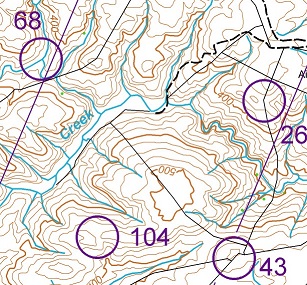
Look at the map. The lines (see through 68) are magnetic north which is where your compass will point. From the track (dashed line) you should be able to follow the fence to 26. From there your should be able to continue following the fence to 43 but beware, the first part is down a hill to the creek bed. (Check that there is a stream junction there abouts.) Then you have to climb back up another hill. But when you are there you should have an easyish route to 104.
The course will be over hills with clear ridges and tops offering good travel, many bush filled gullies and some plantations. The elevation range is from sea level to over 700m.
We hope that you will take the time to enjoy the many and various trees on the course. It is a reminder that these hills are more interesting with native bush in the valleys. For those people familiar with the Port Hills and the devastating fire earlier this year, make sure that you stand up and be counted when there is a call for volunteers to help with replanting the fire affected areas
CCC have organised a programme of restoration planting days, starting on Thursday 25th May and extending to Sat 5th August, with planting happening on both Kennedy's Bush and Marley Hill sites. Note that this is a bring-you-own-spade event
With up to 80 volunteers possible on each day, free transport thanks to Ecan is being organised on each day by bus from Princess Margaret Hospital. No parking up the hill. So it is essential to register before hand. A couple of days are already fully allocated, so be in quick.
To cope with registration, CCC have passed this to Eventfinda. If you are familiar with Eventfinda; fine. Otherwise the following might be helpful:
port-hills-volunteer-restoration-planting
Prizes
Time for Trees
Prizes for the event will be native trees provided by CJ's